Cloud Types: Identification Basics
An Intro to Clouds
Here at Untamed Science, we love clouds. Why? First, clouds are such a cool dichotomy; they are simultaneously more and less than what they seem. They look as though you could make them your soft, fluffy bed in the sky, but in reality you would fall right through them and get whacked with little water droplets if you tried (trust me, I have).
Clouds are fragile, fleeting and powerful. A cloud can change from a fair weather cumulus to an angry, ominous hail-producing nimbus is a few short moments, like an Amazon princess whose delicate features belie her warrior strength…or something.
We also love clouds because they are easy and fun to observe. The more you observe, the more you begin to make connections about clouds as indicators of different types of weather. So here’s a little video about the basics: the three main cloud types and what they can tell us about the weather.
How are Clouds named?
Clouds are pretty much named based on their basic shape, how high they are found in the sky, and if they produce rain or other precipitation. The trick is, it’s all in Latin. So saddle up and let’s get our Latin on.
The shapes :
Cumulo means “heap,” like a heap or pile of cotton in the sky.
Strato means “layer,” like a blanket that covers the sky.
Cirro means “curl of hair,” like wispy baby curls in the sky.
The heights:
High – Cirro also means “high” – above 20,000ft
Middle – Alto means “mid”, like middle – 6500 – 20,000ft
Low – Well there’s not a prefix for “low” in cloud talk, but low clouds are found from 0 – 6500ft.
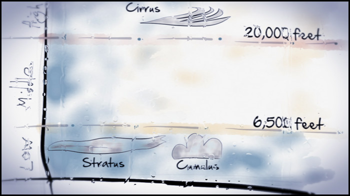
Nimbus means “rain” or “precipitation”
We have all this so instead of saying, “About midway up yonder, those are the puffy clouds,” you say, “Those are Altocumulus.” Isn’t that much more lovely? The answer is yes.
So really much of naming clouds is just a combination of the latin roots above. Let’s have a quiz!
What is a high level blanket-looking cloud called?
High + Blanket-looking = High level blanket
Cirro + Stratus = Cirrostratus
See! It’s fun and easy to speak cloud! There are lots and lots of different types of very cool clouds (with other very beautiful Latin names), but those are the basics of the main three cloud types.
What can clouds tell us about the weather?
One really fun reason to learn about clouds is that you can really tell a lot about the weather by recognizing the different types. Weather is a very complex topic, and this is a small sample to help you on your way to understanding more about it. Listed below are the three major cloud types and what they generally mean in the sky.
Your new love of Latin will come in handy as you decode the names below!
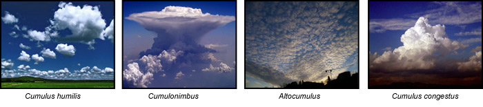
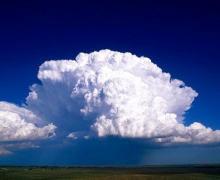
Cumulus
Cumulus are the puffy, white, cotton-top clouds that look so soft that you picture angels lounging around and doing their thing on them. They are considered low-level clouds (below 6500ft), but some forms can build up past 20,000ft. Cumulus comes in many varieties, and here are just a few.
Cumulus humilis is the quintessential Cumulus – flat-bottomed and puffy like cotton (they look like cartoon Simpsons clouds). They are found scattered randomly through the sky in separate little piles, and they are said to indicate “fair weather,” meaning no precipitation and moderate temperatures. They get the name humilis (meaning humble, lowly, small) because they are the tiny, non-threatening Cumulus. If you’re spending a day outside on the slip n’ slide, you will be happy if you see Cumulus humilis.
Other forms of cumulus clouds:
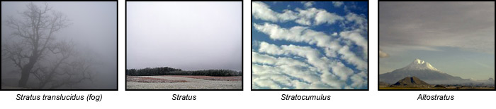
Stratus
Stratus are another low level cloud (below 6500 feet), and they often cover sky like a low-lying blanket. They may or may not produce any precipitation, but if they do it is a misty drizzle.
They are the cloud you might associate with a dreary, curl-up-with-a-good-book day (but I rather like to go on walks on days like that). I like to think about all the action going on above the clouds, and I like taking off in a plane, flying up through the stratus layer, only to find it’s a beautiful sunny day on the other side.
Other forms of Stratus clouds:
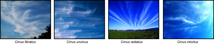
Cirrus
Cirrus clouds are a high-level cloud (above 20,000 ft.), and they are made of icy crystals. These wispy, delicate-looking clouds arrive in advance of frontal systems, so they indicate the weather is about to change.
I love the way cirrus clouds can appear across the sky like they were wistfully painted with a giant cloud brush. They have a whimsical quality that makes them seem more like art than part of the weather.
Other forms of cirrus clouds:


whoah this blog is excellent I like studying your
posts. Keep up the good work!